|
FINDING YOUR WAY TO A SPOT AT SEA
by Dr. Ray McAllister
How often have you been on a good spot for diving or fishing, usually well within sight of the beach, and wondered how you could return there another day? This is even more the case for the small boat operator who does not have sophisticated electronics; Loran, radar, or GPS! Or, in another instance, have you ever dropped a valuable fishing rod, dive equipment, an outboard motor, etc. over the side and wondered how you'd ever find it when you could get a back with SCUBA gear?
There is a relatively simple way of preserving the location well enough to permit finding the lost materials, or a lost anchor. It involves the use of ranges, also known by fishermen as "marks". Before I explain, let me tell you that the H-bomb lost over the ocean off Palomares, Spain, when an American bomb-carrying aircraft blew up in midair, was found because a Spanish fisherman saw the accident and observed a silvery object falling under a parachute after the explosion. He lined up a range that gave him at least one line of bearing along which U S Naval authorities were able to search and along which they found the H-bomb. By the way, all he got for it was a gold watch according to scuttlebutt!
Here is how it works. All you need is one Mark I, Mod I eyeball, in good functioning condition. A basic rule of geometry states that you can only draw one line thru any two separated points on this earth. Try it with a sheet of paper. Such a line is called a "range".
Another simple rule states that two such lines, if they do not lie on top of each other, can only cross at one point. We call the lines "ranges" and the points "marks". Look at the sketch below which shows how this works.
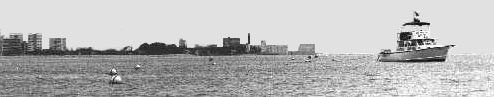
The marks, or points, are well defined sides of buildings, elevator boxes, water tower legs, church steeples, Florida Power and Light smokestacks, etc. Rarely, and only for short time use, we can even use trees, telephone poles, and other more temporary structures. Obviously, if you intend to return to the spot in two years, pick something rather permanent. To came back next day and recover a lost anchor, trees may be permanent enough!
Now let me give you the basic rules which I use to return to an exact spot on the water, more accurate than Loran or radar or ordinary GPS. Indeed, I can usually return to within 6-10 feet of a given spot. These rules are the basis for, and are in the front of my two "Diving Locations" books, available in most dive shops, bait and tackle shops and in some marine stores, between Tequesta and Dania. They give the exact locations for about 100 good diving and fishing spots, wrecks and reefs off SE Florida. 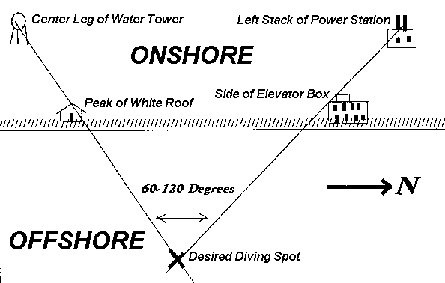
Rule 1. For maximum accuracy, be sure points chosen are sharp and clear, for example, the peak of a roof, the side of a building, a radio antenna, tree trunk, or water tower leg.
Rule 2. WHEREVER POSSIBLE, CHOSE TWO POINTS WHICH ARE WIDELY SEPARATED. THE FARTHER APART THEY ARE, THE BETTER DEFINED IS THE STRAIGHT LINE THEY DETERMINE. Usually, the best combination is an object near US #1, or west of the Intracoastal Waterway, over one on the beach.
Rule 3. Maintain an angle of 60 to 120 degrees between the two lines or ranges for greatest accuracy. Sometimes you have to settle for a smaller or larger angle, but it will not be as sensitive.
Rule 4. Be meticulous about your marks. If you are exactly on your marks you are exactly over your fishing or diving spot.
Rule 5. Write your marks down carefully on 3 by 5" cards which you can keep in your tackle box or dive bag. Your marks are better than anyone elses. Photographs with a telephoto lens are even better!
To use marks as in my books, note the two points indicated on one of the marks; let's say the North Mark. Line up these two points exactly. Now, keeping the marks exactly as shown in the photograph, run in or out until the other set of marks looks just exactly like your Middle or South Mark photos in my book. At that point, drop a small buoy, circle and anchor as desired. While I often give three strip photos, you only need two (the two closest to 90 degrees apart) to find your spot. A few more suggestions may help:
- In choosing new marks of your own, run north past a good spot which you have buoyed. Note which objects on land appear to move fastest in relation to each other. Use fast moving marks where possible, for they are farthest apart. See Rule 2 above.
- Take your own marks. They are better than anyone elses, except for photographic marks as in my book.
- If you lose a range behind a new building, travel out the other range until a depth sounder or towed diver sees the ledge. Sometimes a less prominent object will line up and help recover a lost mark.
- A length of line wound on a gallon bleach bottle, with a small anchor at the end, will unwind rapidly and makes a good buoy.
- The mark farthest away will travel in the same direction as your boat! If the distant mark needs to go north to line up with the near mark, your boat should go north.
I have used this technique in Bermuda, about 6 miles from the beach, to return to old wrecks which we had discovered there. In Florida, where there are no hills, the "marks" technique is probably limited to spots which are 3 miles, or so, offshore. Beyond that it will be hard to see low objects on the beach. The "Esso Bonaire", off Jupiter Inlet, is close to the limit for good marks locations by eye.
Using these simple rules you can return to an EXACT spot where you have been before! They are foolproof, very simple and require NO electronics. Try the technique and, incidentally, buy my books, which have been divers and fishermans bibles in the SE Florida area for 25 years. One is called "Diving Locations, Boynton Inlet to Dania Pier, Including the Tenneco Platforms". The other is "Diving Locations, Boynton Inlet to Jupiter Inlet" Fishermen will know them as "Fishing and Diving Locations"!
A quick note about GPS and Loran. They will both get you to within 60 feet to several hundred feet of a spot for which someone has given you the numbers. Loran is often far off in the S Florida area where "marks" work best. GPS signals are degraded by the Department of Defense (for military secrecy-to which I say B--S--). The result is that you can get only as close as the level of degradation, where they deliberately put an error in the signal. Worse, the error is changed from time to time so you cannot be sure of getting back the next day. However, both will return you fairly close to the spot where you have taken your own Loran or GPS numbers IF GPS degradation has not been changed since you took your GPS location.. So get close with Loran or GPS and get precisely on the spot using the "marks". Most of us have at least one eyeball in functioning condition!
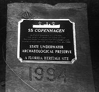
The sketches show you how "marks" work, and a typical site, one of the Florida Underwater Archaeological Preserves, the wreck of the "Copenhagen", off Pompano Beach!
|