|


 |
|
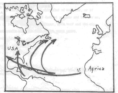
Planetary winds and hurricanes CO2 and water vapor are important factors affecting the rise and fall of sea level, as precipitation in high latitudes cools and freezes, building larger ice sheets. CO2 is a major cause of global warming and, of course, water vapor cools and falls as snow which builds the continental glaciers and ice caps! It should come as no great surprise that our Florida boating weather, and especially our hurricanes, are also water vapor and global weather mediated. In the official hurricane season we have special weather conditions discussed below. A few, but very few, tropical cyclones (the proper general term for hurricanes, typhoons, willy-willies and baguios) occur outside the official season of the hemisphere in which the observer resides. These tropical cyclones, not to be confused with tornadoes that are also called cyclones, generally have winds spiraling in toward a lower pressured central eye. The system rotates counterclockwise in the Northern Hemisphere, clockwise in the southern. Ordinary squalls with winds over 65 knots or 75 mph are not called hurricanes unless the well developed circulation and central low pressure, etc., occur and they are in season, germinating in the tropics or subtropics over the ocean. I suspect you all know of the planetary wind belts that encircle your planet. They look about like the accompanying sketch, except that large masses of land tend to have a great disturbing influence on them. Nonetheless, in a general way, they indicate the direction from which almost all storms come, year round at any given latitude. This heat, hidden before, now becomes sensible or able to be felt and heats up adjacent air. Heated air expands. Expanding air pushes out other air. Moving air is wind. A lot of moving air in an unstable easterly wave becomes a hurricane or typhoon. Thus warm ocean water, the sun and meteorological conditions on our planet generate hurricanes. It is worth noting that there are some feedback mechanisms working to keep our atmosphere relatively stable. Even though water vapor rises toward the top of the atmosphere, it condenses into water droplets because of the decrease in temperature with height. The cooling (the adiabatic lapse rate) is at a rate of about 5.5 degrees F per thousand feet of rise. This causes the condensing water vapor to become clouds, then rain or snow and fall back to the lower atmosphere and the ground. Otherwise we might have lost most of our water a long time ago and we could have a Martian type of surface; dry and dusty with an atmosphere mostly of CO2 and N2. There are several main tracks for hurricanes, but dont be complacent. Any given storm may cut across these general paths or occur farther east, west, north or south of them. With the Horse Latitudes, a belt of descending air over the Bermuda, Azores area and elsewhere, we get a pileup of air called the Bermuda High. South of it, winds blow from east to west, north of it from east to west. South of it, the waters of the North Atlantic Ocean are warm, often reaching 80-86 degrees at the surface. Evaporation is enhanced. A series of fluctuations in the easterly flow, called easterly waves, occur about every 800-900 miles in this wind belt. Such waves are normal and have no major consequence unless they became unstable. When that happens, the normal pattern of bad weather behind an easterly wave changes to bad weather in front of the wave. Of about two easterly waves a week to pass one of the Antillean Islands, usually less than a dozen a year (on the average) grow to hurricane strength. For hurricanes, however, the range is from one in 1980, 1914, and 1925 to 21 in 1933 and 17 each in 1887 and 1936, so dont count to twelve and then get complacent. As the ocean gets warmer and water vapor rises from its surface, this H20 gas is lighter than any of the four main constituents of air. Oxygen, nitrogen, argon (an inert gas making up about 1 percent of our atmosphere), and CO2, are all heavier than water vapor. The water vapor rises through the air. When it reaches its dew point, the atmospheric temperature level where vapor becomes water droplets, the water vapor gives up the heat it is holding as latent heat and as noted above, a hurricane may result! Pay close attention to your National Hurricane Center bulletins. When an unstable easterly wave develops circulation, watch it for it may progress through a tropical depression to a tropical storm and thence, at 74 MPH, to a hurricane. There are 5 categories of hurricanes, determined by the top speed of winds in the storm. From 74 to 95 MPH it is a Category 1 storm. From 96 to 110 it is a Category 2 hurricane. 111 to 130 makes it a Category 3; 131 to 155 and you have a Category 4 and anything over 155, thank God, rarely seen, is a Category 5 hurricane with enormous destructive power. Boats and Hurricanes Boats and hurricanes go together like red flags and bulls. When hurricane season starts we ought to understand these great (and valuable) storms. They are great storms because of the enormous amount of energy expended by such a storm and the huge area that it covers. For example, a storm 500 miles across covers about 200,000 square miles. They are valuable because they provide a very significant part of the rain that falls on the southeastern US. in any decade, and many years of that decade. It has been said that without hurricanes the Southeast United States would be semiarid The driving force for hurricanes is the sun. It warms the equatorial Atlantic and evaporates a large amount of water. Each gram of this water carries in its vapor at least 540 calories of heat in latent form; that is, it cant be felt or measured while in the vapor. (There are 250-300 grams per glass of water.) Water vapor is lighter than air and rises until the temperature gets low enough, in the atmosphere a few thousand feet up, to condense the vapor, at which time this latent heat is released. As it is dumped into the surrounding air it heats the air. Heated air expands. Expanding air moves. Moving air is called wind. A big enough wind circling about a central eye or low-pressure area is a hurricane. The ability of this latent heat of vaporization to fuel a hurricane (or the equivalents in other oceans: typhoon in the North Pacific, willy-willy in Australia, baguio in the Philippines, cyclone in North Indian Ocean, is legendary. A hurricane which nearly lost its identity over the mountains of Cuba regenerated from perhaps 40 MPH to 120 MPH winds just crossing the warm Gulf Stream from CUBA TO Florida City, Florida. The total energy of a typical hurricane has been likened to 1000 Hiroshima-type atom bombs. No wonder sailors fear them. Typhoons are sometimes more than twice as fearsome as hurricanes in terms of wind velocity. AND remember that wind damage increases as some power of velocity increase; double the velocity and quadruple the damage potential. And what does this mean to a sailor? Well, if caught at sea, get all the distance possible from the shore or any reef. Depending upon the strength of the storm and the seakeeping qualities of your boat, you may wish to run before the storm under bare poles, or heave to behind a sea anchor with bow to the seas, button up and pray a lot. But a prudent modern sailor should maintain a regular weather watch on your local radio station, or better yet, monitor the National Hurricane Center bulletins during hurricane season. Except under extraordinary conditions you should never be far from a safe anchorage during one of these dangerous storms. If in port, there are still some major precautions to take. Well, in advance of a hurricane decide where to lay up your boat, and get written permission if it is in someone elses waterway, or at the time of the storm, you may find yourself competing with 50 other boat owners. Make a trial run to the hurricane hole which you choose and decide how you will moor your boat. Remember that big trees may be uprooted by such storms, so choose your mooring points well. Multiple lines are better than one or two. Have more than adequate rope of good condition and preferably synthetic (particularly nylon, which has excellent elasticity). Chafing gear is a must for all points at which the line touches the deck, rail, tree or other object. Two good anchors, plenty of chain or other weight for the anchor shank, and enough anchor rode are also excellent additional precautions. If you have an engine, a full fuel tank would not be amiss. Now hope for no hurricanes. When one does come, however, you will stand a good chance of coming through safely. As you go through the real exercise, start early. There is nothing more pathetic than the crush of boat owners trying at the last minute to get to safe anchorage, often as the storm starts to rage about them. Be sure to allow for a storm surge or storm tide, the several feet of sealevel (and canal level) rise due to strong winds pushing water onshore and into the inlets The maximum storm surge for SE Florida might reach 10 or 11 feet in a severe storm. God forbid that we get one anywhere near that serious. If you should stay aboard make sure the engine starts and runs well. Remember that the eye of the storm is essentially calm. This is not an old wives tale: Ive been in the eye of three hurricanes in my life and have gone outside to check the blankets nailed over the windows, to swim out and bail out my boat and even to sightsee briefly, once under clear blue, sunlit skies. In a few minutes, the storm will hit you on the opposite side of the eye with dangerous winds from the opposite direction, so stay close to shelter. It is a good time to check all lines and chafing gear if you are careful, for the opposite storm wall is not long coming! Lets go back to our hurricane again. Driven by the latent heat of vaporization the hurricane usually forms in the North Equatorial Current of the tropics and comes from the east in its early stages. As it builds and circulation develops it begins to rotate counterclockwise in the northern hemisphere. The rapidly moving air slowly spiraling from higher pressure near the edges of the storm toward the low pressure in the eye. Such pressures may get as low as 28.5 inches of mercury or 900 millibars pressure. At the same time the hurricane moves forward, from east to west, embedded in the NE Trade Wind belt and approaches Florida. As it moves it often slowly curves northward until it reaches the Westerly Wind belt and recurves back to the east, usually across the N. Atlantic. Some maintain considerable power all the way to Bermuda and do considerable damage there. There are three main tracks which hurricanes follow. For some years most Atlantic hurricanes will curve north well seaward of the Bahamas, threatening Bermuda but not the mainland. Then a shift to one of the other general tracks will occur. One of these runs west of Florida and such storms run through the Caribbean Sea and usually into the Gulf of Mexico, then into Mexico and the southern US. It is the third track that Florida fears. It brings storms north up the islands, across Puerto Rico and Hispaniola, and across the southern Bahamas or eastern Cuba and across the northern Bahamas, the Straits of Florida or the Florida mainland. These are the storms with the greatest potential for damage in this part of Florida and we finally had a bad one in Andrew!
As the storm circulates counterclockwise, it often develops winds considerably higher than the 75 MPH required for it to be called a hurricane. Winds of 200 MPH have been estimated for Camille and others of the past 20 years. The forward speed of the storm varies greatly but may reach 40 MPH in some instances. Usually in the tropics, forward motion will be at 5-15 MPH. As it recurves it may speed up. Lets look at a 100 MPH hurricane moving north toward South Florida at 20 MPH.
It is a matter of enormous luck whether you are just into the dangerous quadrant and your boat is destroyed, or on the other side of the eye and can stand on deck as the storm goes by, windblown but relatively safe. Often those few miles are the difference between life and death as it was for Cameron, Louisiana during hurricane Donna, somewhere in the 1950s. Since hurricane prediction is at best, an inexact science, assume the worst and prepare for it, for a REAL hurricane, like Andrew is a devastating natural phenomenon. We had been spared for many years during which weve built seaward of the dunes, right on the beach. Most boat owners have experienced 40 or 50 MPH winds and just do not have any idea how serious 100 or 150 MPH winds are. Think what, for example, would happen if sealevel were raised 10 feet by a serious storm coming from the east. Waves would not break on beaches. They would break on dunes, condominiums, private homes and stores along the water front. None but the dunes are made to resist wave attack and even they dont do too well. Water would rise well over docks, perhaps high enough to lift lines over pilings or to set boats down on pilings, docks, seawalls etc. This latter is a very real danger, while riding out a hurricane at dockside. Weve not discussed small boats yet, boats in the 15 to 25 foot range. If you can trailer them, get them out of the water and into a garage or warehouse. If this is not possible place the trailer in the yard, hopefully where no tree will fall on it, on the lee side of the house with reference to the right front quadrant of the hurricane where the high winds are. Tie it down to the best soil anchors you can. Screw auger soil anchors are useful and so are jetted in soil anchors. Trees, if sturdy, with good root systems, are fine for tie downs. It helps to let air out of trailer tires too, both to make rolling harder and to lower the center of gravity. By all means tie the boat to the trailer and both to the anchors. Filling the small boat partly full of water is risky. While it adds weight which helps hold the boat down, if one has a wet hurricane, enough more rain may fall to break the boats back or damage the trailer. At least be prepared to pull the plugs on the boat if heavy rains start. Naturally all removable portions of the boat, cushions, Bimini top, gas cans, etc. will be inside the house for the duration. Now pray that the worst of the storm passes with you and your boat in the safe quadrant. Hurricane Surges and Waterfront Homes Driven by the strong onshore winds of a hurricane, the hurricane tide or surge is the biggest cause of damage to waterfront homes. The wind piles up the water to heights of 25 feet or more on the Gulf Coast, 30 feet or more in Bangladesh, but, hopefully, only to a maximum of 11 feet along the SE coast of Florida. The Gulf Stream, carrying away the water as it piles up, is the reason for our relatively small storm surge! Nonetheless, 11 feet of water level rise would do great damage in our area. My house is 8.05 feet about sealevel! Eleven feet of sealevel rise requires a category IV or V storm, and we have not had one on this coast since the early 1900's. We are statistically overdue. My mother showed me an oil line in the rafters of the Mathieson barn, on Key Biscayne, about 11 feet above mean sea level, from an early 1900 hurricane. Now lets see how it affects us! If the surge occurs precisely at high tide, add another foot and a half to the 11 feet. At low tide subtract a foot and a half. Add a little more if it occurs at syzygy (full or new moon). Thus luck has a lot to do with the extent of the damage done. If you live on the Intracoastal Waterway (ICWW), your distance from the nearest inlet will be very important. Close to the inlet the tides will be almost as high as along the ocean front. The water pushed thru the inlet by the storm will be delayed by friction with the bottom and sides of the ICWW and the rise will be smaller and smaller as you get farther from the inlet. It is quite likely that, for a storm traveling at average speed, that it will blow past before the full extent of the surge reaches homes even a short distance from the inlet. But if the storm stagnates and sits just offshore, the full surge may have time to develop and water damage can be extensive. SE Florida has another great advantage. We have offshore reefs, a mile out, which come to within 45 feet of the surface. These drag on the bottom of large waves and trip them. For this reason the waves that eventually reach our beach are relatively small in the shadow of the Bahamas and the offshore reefs. The same topography tends to slow the storm surge somewhat and make it less severe than it would be where such a reef does not exist. Another big advantage accrues to the people who live behind the large sand dunes that nature provided along our coast. Boca Raton has seen fit to preserve a significant part of its dune system, which acts as a dam against very high storm tides. Where the dunes have been bulldozed out to permit low lying beachfront dwellings, the water may well surge across the gaps and erode under the foundations of such buildings, destroying anything not built to hurricane code. It should be a very strong reason for anyone on a canal in Boca, Deerfield, Highland Beach or Delray to vote for every beach bond offered. If I have given you the idea that an 11 foot surge is POSSIBLE, I have done well, but it is much more likely that you will see smaller storm surges many times before a big one hits. Remember the number of times you have heard that "tides (really storm surges) 3 to 5 feet above normal can be expected" for a past hurricane? One final caution. If you are infirm or crippled, get away from the waterfront when a hurricane threatens. A stuck bridge, or worse, a destroyed bridge, or a surge flooded road will block your escape and leave you marooned without electricity, water, MEDICAL CARE or other necessities. We have not had a good hurricane in this area for more than twenty years, but I've been in big ones elsewhere and I WILL go west if one threatens, after putting valuable electronics, etc., as high up on tables as possible. Come with me. Our lives are worth more than a lousy house or TV!
|
|
[Home] [Cirriculum Vitae] [FAU Page] [Ray's Corner] |